
3D BIM Modeling and Terrain Mapping of the Drei Tannen Retirement Home
- Nov 18, 2025
- 2 min read
Project Key Facts
Location: Wald, Switzerland
Building type: Retirement Home
Project size: 12,260 m²
Tools/Software: ArchiCAD
Team size: 6 BIM modelers, 1 ArchiCAD expert / Project Manager
Delivery: 10 working days (3D + 2D)
Data Basis
Unstructured and georeferenced point cloud (.e57 format), panoramic images, DXF files with elevation points.
Tools/Software used by our partner
Leica RTC 360 and Leica Cyclone Register 360
Delivered data
Accurate “As-Built” 3D model of the building in LOG300 in Archicad delivered in .PLA and .IFC formats
2D plans in .pla and .ifc formats including:
floor plans
roof plan
terrain plan
4 facades
2 sections
3D model of terain in .PLA and .IFC formats


Project description Drei Tannen Retirement Home
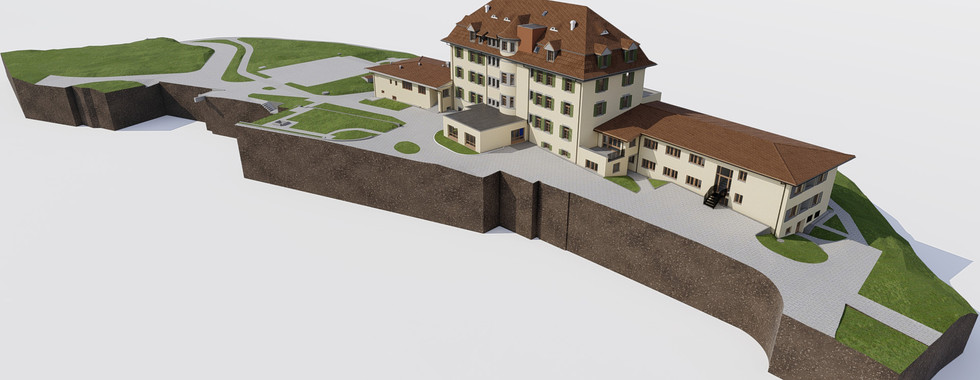
The Drei Tannen retirement home in Wald, Switzerland, consists of a seven-storey main wing, two two-storey side wings, and two single-storey extensions, all surrounded by extensive green areas. A detailed modeling of the terrain and access roads was therefore an important part of the modeling process, ensuring that the building could be accurately represented and realistically integrated into its surroundings.
What is the model being used for?
The model of the Drei Tannen retirement home serves as the basis for the redesign of the building. The two side wings will be demolished, while the centrally located main wing will be preserved and thoroughly renovated.
A particularly important element was the roof structure, which required a high level of detail to correctly model the structural components.
Additionally, a 2D terrain plan with contour lines at 20 cm intervals needed to be created: A time-consuming task due to the large number of elevation points that had to be transferred.
Were there any difficulties or particular challenges in the modeling process?
Interpreting the original building structure was complex, especially in the basement level, where warped walls and irregular structures made the modeling process more difficult.
What makes the project special?
The project stands out due to the complex terrain modeling and the use of multiple data sources, including point cloud data, panoramic images, and topographic data from a text file, which were all combined into a single model.
Were there any innovative methods or solutions applied?
Yes. We combined point cloud data, panoramic images, and topographic data to model the terrain.
This integrated approach enabled exceptionally high and reliable accuracy in both the 3D model and the 2D plans.
What lessons were learned for future projects?
Working with complex terrain and deformed structures once again demonstrated the importance of close coordination among project stakeholders and the precise handling of survey data.
The project was also a valuable opportunity to further develop and optimize workflows for modeling irregular geometries and topographies.
Both the 3D model and the 2D plans were delivered after only 10 working days.
Do you have questions about this project or would you like to discuss a future one with us? Feel free to contact us by email at hello@miviso.com or by phone at +43 512 931824 200.


The point about deformation monitoring surveys being required in high-risk urban construction zones is increasingly relevant as development pushes closer to existing infrastructure. Detecting movement early — before it becomes structural failure — is the whole purpose of this kind of ongoing measurement. For projects in BC where adjacent structures or geotechnical instability is a concern, working with an experienced as-built surveyor who can establish baseline documentation and set up monitoring reference points is an important part of responsible project management.